

Epicenter of Earthquake Was Delhi University: US Geological Survey
According to USGS, the epicentre of Delhi earthquake was just south of Delhi University near GT road, not Delhi-Haryana border as media reports have said. (See UPDATE 26-Nov, 4.15PM)
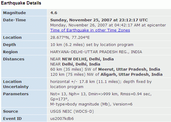
Delhi experienced what's being called a "moderate" earthquake this morning. It recorded 4.6 on Richter scale. I've felt earthquakes in the past and this was by far the strongest because its epicenter was right in Delhi.
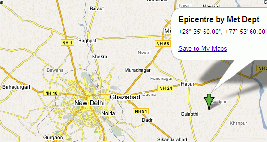
However, there seems to be some confusion over where exactly lies the epicentre in or around Delhi. Media reports mention Delhi-Haryana border but the Delhi Haryana border is not a single location, it stretches for several kilometers. However, the latitude and longitude figures released by India's meteorological department does not match this.
Epicenter According to the Met Department
According to Indiainfo and ZeeNews,
(Scale: 20km)
As you can see, the epicenter according to the met department is not consistent with the statement that it's on Delhi-Haryana border. It's actually about 100km East of the point where Bahadurgarh is. (see UPDATE below)
Epicenter According to U.S. Geological Survey
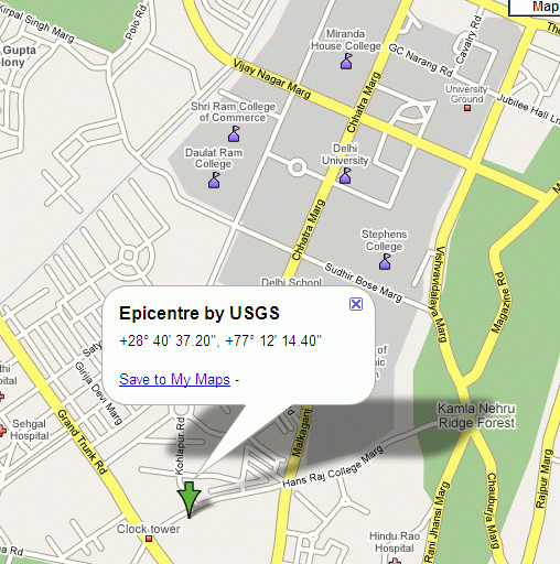
The National Earthquake Information Center (NEIC), part of U.S Geological Survey maintains a database of earthquakes around the world. According to their data, the epicenter location was actually right in the middle of North Delhi just south of Delhi University.
Enter 28.677°N, 77.204°E in Google Maps and you get this.

(Scale: 2km)
(Scale: 500m)
The figures released by USGS have a location uncertainty of +/- 18km but that still doesn't put it anywhere close to the figures provided by the met department.
I will update this post when I have more info but if you know a more reliable source of the epicenter location, please leave a comment.
UPDATE 4.15PM: Correct Met Dept Location Now Confirmed
It seems the media reports picked up wrong Longitude figure released by the Met department. Met Department's list of earthquakes in November available on its website (scroll down to 25) puts the Longitude at 77.0E instead of 77.9E as reported in news reports mentioned above.
This puts their stated location at Delhi-Haryana border near Najafgarh or about 10km from Bahadurgarh. View location on Google Maps.

(Scale: 10km)
The Amateur Seismic Centre (ASC), an independent centre based in Pune, continues to go with the USGS data source and puts the epicenter at Malka Ganj-Kamla Nagar in Delhi University area, as mentioned above.
Note that both USGS and Met department locations are from their preliminary reports.
UPDATE 8.00PM: I wrote to ASC's Stacey Martin to find out which data is more credible. Stacey kindly wrote back that eventually India Meteorological Department (IMD) figures will be more accurate since its monitoring station is in Delhi itself while USGS/NEIC's closest monitoring station is in Kabul. However, as of right now, the latter has provided figures up to three decimal places so at the moment ASC is going with NEIC's epicenter in North Delhi.
Since this is only preliminary data, it's likely to be corrected and the final IMD location will only be available in the public domain in 18-months due to CTBT constraints.
Past Earthquakes in Delhi Region
Here is some historical information on earthquakes in Delhi, taken from ASC report of today's quake.
UPDATE 30-Sep-14 - Useful resources: Sharon Thornton, Research Coordinator at The International Union of Geodesy and Geophysics (IUGG) wrote in to suggest a resource she helped create covering: earthquake data for years 2005 - 2014, most devastating earthquakes 2005 - 2013, earthquake glossary. The resource can be found here: Earthquakes Data Magnitude 5.0 and Over 2005 - 2014. She also suggests two more useful resources: Seismic Monitor and Quakes - Live Earthquakes Map.
Delhi experienced what's being called a "moderate" earthquake this morning. It recorded 4.6 on Richter scale. I've felt earthquakes in the past and this was by far the strongest because its epicenter was right in Delhi.
However, there seems to be some confusion over where exactly lies the epicentre in or around Delhi. Media reports mention Delhi-Haryana border but the Delhi Haryana border is not a single location, it stretches for several kilometers. However, the latitude and longitude figures released by India's meteorological department does not match this.
Epicenter According to the Met Department
According to Indiainfo and ZeeNews,
The epicenter of the tremor was at the Delhi-Haryana border at 28.6 N latitude and 77.9 E longitude. Precisely it was centered around 10 kms from Bahadurgarh in Haryana.This does not make any sense because those figures are for a location in U.P nowhere close to Delhi or Haryana. Enter 28.6°N, 77.9°E in Google Maps and you get this.
(Scale: 20km)
As you can see, the epicenter according to the met department is not consistent with the statement that it's on Delhi-Haryana border. It's actually about 100km East of the point where Bahadurgarh is. (see UPDATE below)
Epicenter According to U.S. Geological Survey
The National Earthquake Information Center (NEIC), part of U.S Geological Survey maintains a database of earthquakes around the world. According to their data, the epicenter location was actually right in the middle of North Delhi just south of Delhi University.
Enter 28.677°N, 77.204°E in Google Maps and you get this.
(Scale: 2km)
(Scale: 500m)
The figures released by USGS have a location uncertainty of +/- 18km but that still doesn't put it anywhere close to the figures provided by the met department.
I will update this post when I have more info but if you know a more reliable source of the epicenter location, please leave a comment.
UPDATE 4.15PM: Correct Met Dept Location Now Confirmed
It seems the media reports picked up wrong Longitude figure released by the Met department. Met Department's list of earthquakes in November available on its website (scroll down to 25) puts the Longitude at 77.0E instead of 77.9E as reported in news reports mentioned above.
This puts their stated location at Delhi-Haryana border near Najafgarh or about 10km from Bahadurgarh. View location on Google Maps.
(Scale: 10km)
The Amateur Seismic Centre (ASC), an independent centre based in Pune, continues to go with the USGS data source and puts the epicenter at Malka Ganj-Kamla Nagar in Delhi University area, as mentioned above.
Note that both USGS and Met department locations are from their preliminary reports.
UPDATE 8.00PM: I wrote to ASC's Stacey Martin to find out which data is more credible. Stacey kindly wrote back that eventually India Meteorological Department (IMD) figures will be more accurate since its monitoring station is in Delhi itself while USGS/NEIC's closest monitoring station is in Kabul. However, as of right now, the latter has provided figures up to three decimal places so at the moment ASC is going with NEIC's epicenter in North Delhi.
Since this is only preliminary data, it's likely to be corrected and the final IMD location will only be available in the public domain in 18-months due to CTBT constraints.
Past Earthquakes in Delhi Region
Here is some historical information on earthquakes in Delhi, taken from ASC report of today's quake.
This is one of the strongest earthquakes in the Delhi region since 2001 and the biggest since 1960. Prior to this latest earthquake, the strongest local earthquakes to have originated within the Delhi metropolitan area since the 1960 Gurgaon earthquake was a Mb=4.3 earthquake in the Dwarka-Najafgarh area on 28 April 2001 that caused minor damage & widespread panic. The strongest known earthquakes in the Delhi region include the M6.0 Khurja-Bulandshahr earthquake on 10 October 1956, the M6.0 Gurgaon earthquake on 27 August 1960 and the Mb=5.6 Moradabad earthquake on 15 August 1966. Historically, the 15 July 1720 earthquake in the Delhi region caused the greatest damage in the city causing many deaths and widespread damage including knocking down large parts of the Shaharepanah (city wall) in Old Delhi from Kabuli Gate to Lal Darwaza and the battlements of the Fatehpuri Masjid.
UPDATE 30-Sep-14 - Useful resources: Sharon Thornton, Research Coordinator at The International Union of Geodesy and Geophysics (IUGG) wrote in to suggest a resource she helped create covering: earthquake data for years 2005 - 2014, most devastating earthquakes 2005 - 2013, earthquake glossary. The resource can be found here: Earthquakes Data Magnitude 5.0 and Over 2005 - 2014. She also suggests two more useful resources: Seismic Monitor and Quakes - Live Earthquakes Map.
 I've just spent the last three hours learning about Ron Paul, a U.S presidential candidate I knew nothing about earlier and one who has recently experienced an unusually strong upsurge of support surprising many. TIME is calling it